relevant persons information
legacy wellhead decommissioning
Chevron Australia operates the Gorgon and Wheatstone natural gas developments located off the northwest coast of Western Australia (WA), as well as holding various other interests in the region.
In accordance with the Offshore Petroleum and Greenhouse Gas Storage Act 2006 (Commonwealth) (OPGGS Act), we are planning to remove nine non-operational, legacy wellheads and associated infrastructure.
Chevron Australia is currently developing a Legacy Wellhead Decommissioning Environment Plan (EP) which will be submitted to the National Offshore Petroleum Safety and Environmental Management Authority (NOPSEMA) for assessment.
This information sheet is intended to assist ‘relevant persons’ to make an informed assessment of the environmental impact and risks of our activities and to provide input and feedback to enhance the EP, including control measures to manage environmental impacts and risks of the activity.
Relevant persons are those whose functions, interests or activities may be affected by our activities. This includes Traditional Owners and Custodians with a spiritual and cultural connection to Country, commercial and recreational fishing, tourism, individuals or groups in local communities.
Please note: in the context of an EP, each of the following is considered part of the ‘environment’:
- an ecosystem and their constituent parts, including people and communities
- natural and physical resources
- the qualities and characteristics of locations, places & areas
- the heritage value of places; and
- the social, economic and cultural features of the above.
location and water depth
The location of each wellhead is shown in Table 1 and Figure 1 and Figure 2.
The operational area (OA) in which the petroleum activities described in the EP will be undertaken is defined as a 1.8-kilometre (km) radius buffer around each wellhead.
Water depths within the OAs range from approximately 130 metres (m) to 1,350 m. The OAs are located more than 50 km from the Montebello Islands, 63 km from Barrow Island, and 135 km from the mainland coast of WA.
Jump to detailed maps below
activity summary
The nine wellheads have been plugged and accepted as permanently abandoned. This means permanent cement plug barriers have been installed in the wells to prevent hydrocarbon release to the environment.
The decommissioning activities outlined in the EP will include:
• removal of wellheads and associated infrastructure
• vessel operations, including an offshore Inspection, Maintenance and Repair (IMR) vessel, general support vessel and use of Remotely Operated Vehicles (ROVs); and
• pre and post-removal ROV surveys.
The vessels will operate on dynamic positioning (DP) and will not require bunkering (refuelling) at sea.
To enable access to the wellheads, marine growth removal may be undertaken via an ROV using high-pressure water and/or brushes. To help facilitate wellhead removal, relocation of sediment within ~5 m radius of well infrastructure may be required.
Wellhead infrastructure will be removed using either a diamond wire saw, internal abrasive cutting tool or mechanical internal cutting tool. Tool selection will be based on water depth, wellhead structure, access and other factors.
Wellheads and associated infrastructure will typically be removed at or below the seabed. However, in cases where the diamond wire saw is utilised, up to 1 m of infrastructure may remain above the seabed.
schedule and duration
Wellhead removal activities are planned to commence in 2027. Activities may take place over multiple campaigns and are expected to be completed within a 5-week window.
This timing is indicative and subject to vessel availability, delays caused by weather events, and other unforeseen factors.
It is expected works will be undertaken 24 hours per day and 7 days per week for the duration of the activities.
safe navigation area and marine exclusion zone
The OA encompasses a 500 m safety exclusion zone around the vessel undertaking removal works for the duration of the activity.
environment that may be affected (EMBA)
As part of our environmental assessment and consultation process, Chevron Australia create an EMBA map to provide geographical context for stakeholders to determine if their functions, interests or activities may be affected by an offshore activity during operations or in an emergency scenario.
Figure 2 shows the EMBA, which is based on a worst-case environmental scenario, which in this case is an unplanned release (oil spill) from a vessel collision.
The EMBA has been defined through combining 100 simulations for each unplanned release scenario under different weather and ocean conditions. This means that in the highly unlikely event an unplanned release does occur, a geographical area much smaller than the EMBA would be affected.
The majority of the impacts or risks directly arising from planned wellhead removal activities would occur within close proximity of the OA.
Chevron Australia has systematic control measures to prevent and mitigate emergencies and to reduce the impact of planned activities on the environment, including ecological, social and cultural sensitivities.
Table 2 summarises the key impacts or risks and proposed control measures to manage these to levels that are as low as reasonably practicable (ALARP) and acceptable.
marine fauna and biologically important areas
Marine fauna that may be found at each wellhead location are predominantly pelagic and deep-sea demersal fish species.
Some threatened and/or migratory fish species (e.g. whale sharks, other sharks and manta rays) may be present in the area; however, these are primarily coastal species or are associated with shallower water or features (e.g. seamounts and reefs).
BIAs for several marine fauna species overlap the EMBA, including the humpback and pygmy blue whale.
cultural values
Chevron Australia acknowledges that Traditional Owners and Custodians in the northwest region of WA have expressed a cultural and spiritual connection to Sea Country. This encompasses an obligation to protect cultural values and features — including songlines, dreaming stories, and the flora and fauna connected to them.
We are committed to ongoing engagement and consultation with relevant groups to protect these cultural values (tangible and intangible). This process will continue to inform our understanding and help facilitate the co-design of appropriate controls to avoid impacts.
Chevron Australia’s Cultural Heritage Management System (CHMS) sets out processes and procedures to manage risks to cultural heritage, and Chevron Australia’s obligations under relevant legislation including the Aboriginal Heritage Act 1972 (WA) and the Underwater Cultural Heritage Act 2018 (Commonwealth).
The CHMS includes governance of field surveys and monitoring, spatial data, compliance and assurance, heritage assessment, inadvertent discovery procedures, incident management, training and induction materials.
approvals process
Petroleum activities in Commonwealth waters are regulated by NOPSEMA. Before petroleum activities can take place, Chevron Australia must develop an EP which will be assessed by NOPSEMA in accordance with the requirements of the Offshore Petroleum and Greenhouse Gas Storage (Environment) Regulations 2023 (the Regulations).
The Regulations require us to consult with relevant persons whose functions, interests and activities may be affected by the petroleum activity.
Following consultation, we will submit the EP to NOPSEMA, which will:
• describe the environment in which activities are planned to take place;
• include an assessment of environmental impacts and risks arising from the activities;
• identify control measures to manage the potential impacts and risks to levels that are ALARP and acceptable; and
• outline how Chevron Australia has engaged with relevant persons and how their feedback has been considered and addressed.
NOPSEMA will assess whether the EP satisfies the Regulations, including whether the environmental impacts and risks of the activity will be managed so that they are ALARP and acceptable before accepting the EP.
impacts, risks and proposed controls
A summary of impacts/risks and key proposed controls for Legacy Wellhead Decommissioning activities can be viewed in Table 2.
your input
We are now seeking your feedback and input if you consider your functions, interests, or activities may be affected based on the information provided, including the summary of the key environmental impacts and risks identified to date in Table 2.
We encourage you to provide additional details about the environment, aspects, consequences of the activity or control measures or to ask for further information or consultation by 19 November 2025.
You can contact us with any questions, requests for information, or to provide feedback by calling tollfree on 1800 225 195 or online below.
Relevant persons may request that the information they provide be treated as confidential. Chevron Australia will make this known to NOPSEMA and it will be identified as sensitive information and not published in the EP.
what's next
The feedback we receive during consultation will be used to inform and enhance the EP before it is submitted to NOPSEMA for assessment.
We commit to keeping you informed and providing responses to any relevant person who so requests.
privacy notice
If you choose to provide feedback on this proposal, Chevron Australia will collect your name and contact details, in addition to your comments, for the purposes of maintaining contact with you and inclusion of your feedback in our submission to NOPSEMA. Provision of this information is purely voluntary, however if you choose not to provide it, we may not be able to contact you in the future regarding your submission. Chevron may transfer your information to NOPSEMA, if required and if you do not identify it as sensitive, and to other Chevron affiliates including our head office based in the United States. For further information regarding how we protect your personal information, and your rights, please refer to our privacy notice.
further information
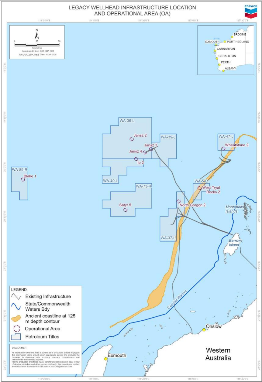
Figure 1: Legacy wellhead infrastructure location and operational areas (OA).
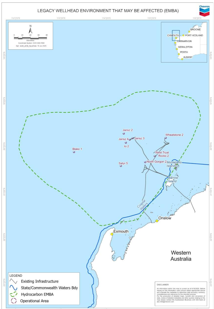
Table 1: Location coordinates and water depths of legacy wellheads and associated infrastructure. – view here
Table 2: Summary of key potential impacts and risks and key proposed control measures for wellhead removal activities. – view here
resources
- Consultation on Offshore Petroleum Environment Plans – NOPSEMA pdf opens in new window
- Environment plan content requirements – NOPSEMA pdf opens in new window
- Environmental requirements – NOPSEMA opens in new window
- NOPSEMA Assessment Process Environment Plans opens in new window
- Offshore Petroleum Greenhouse Gas Storage (Environment) Regulations opens in new window
- Chevron Operational Excellence Management System (OEMS) opens in new window
- Consultation in the course of preparing an environment plan – NOPSEMA pdf opens in new window
- Legacy wellhead decommissioning– relevant persons information sheet pdf opens in new window