relevant persons information
gorgon stage 3 drilling
Chevron Australia, on behalf of the Gorgon Joint Venture, operates the Gorgon Project, located off the northwest coast of Western Australia (WA).
Since 2015, as part of the first phase of the Gorgon Project (the Gorgon Foundation Project), offshore production wells, in-field infrastructure, and production pipelines have gathered hydrocarbons (natural gas and condensate) from the Gorgon and Jansz-Io gas fields and transported it to the Gorgon Gas Treatment Plant (the Gas Plant) on Barrow Island.
Hydrocarbons are processed at the Gas Plant for export as liquefied natural gas (LNG) or piped to the mainland for WA domestic gas users.
The existing Gorgon Project environmental approvals envisaged the development of backfill fields within the Greater Gorgon Area as supply from the Gorgon and Jansz-Io fields depleted over time.
This next phase of the Gorgon Project, the Backfill Fields Development, comprises the production of natural gas from seven backfill fields within the Greater Gorgon Area: Chandon, Chrysaor, Dionysus, Eurytion, Geryon, Semele, and West Tryal Rocks. The seven backfill fields will be developed or co-developed over multiple stages.
These backfill fields will connect to Gorgon Foundation Project infrastructure in order to maintain current rates of production at the Gas Plant on Barrow Island.
The development of the seven backfill fields is described within the Gorgon Backfill Fields Offshore Project Proposal (OPP), which was accepted by the National Offshore Petroleum Safety and Environmental Management Authority (NOPSEMA) in October 2025. After an OPP is accepted, further consultation must be undertaken, and an Environment Plan (EP) must also be in place before an offshore petroleum activity can commence.
The first of the backfill fields to be developed are the Geryon and Eurytion (G&E) gas fields, referred to as Gorgon Stage 3 (GS3).
Chevron Australia is currently developing the Gorgon Stage 3 Drilling Environment Plan (the GS3 Drilling EP), which will be submitted to NOPSEMA for assessment and acceptance.
The installation of other GS3 infrastructure, and tie-in (connection) to Jansz-Io infrastructure, which will allow for the transport of G&E hydrocarbons through the existing Jansz Feed Gas Pipeline to the Gas Plant, is within scope of a separate EP [1].
This information sheet is intended to assist ‘relevant persons’ to make an informed assessment of the potential environmental impacts and risks of our activities and to provide input and feedback to enhance the development of the GS3 Drilling EP.
Relevant persons are those whose functions, interests or activities may be affected by our activities. This includes Traditional Owners and Custodians with a spiritual and cultural connection to Country, commercial and recreational fishing, tourism, and individuals or groups in local communities.
Please note: in the context of an EP, each of the following is considered part of the ‘environment’:
- an ecosystem and their constituent parts, including people and communities
- natural and physical resources
- the qualities and characteristics of locations, places and areas
- the heritage value of places
- the social, economic and cultural features of the above.
[1] A separate information sheet and consultation period with relevant persons will be undertaken for the GS3 Pipelay, Subsea Installation, and Pre-commissioning EP in 2026.
activity summary
The petroleum activity covered by the GS3 Drilling EP includes:
- drilling and completion of six new subsea production wells (including installation of horizontal subsea trees) within the G&E fields
- inspection, maintenance, and repair (IMR) activities, if they are required to occur prior to GS3 commissioning, start-up and operations
- general field support operations (e.g. use of vessels, helicopters, Remotely Operated Vehicles (ROVs) or Autonomous Underwater Vehicles (AUVs) to support the above activities).
subsea production wells
A drillship or semi-submersible mobile offshore drilling unit (MODU) will drill and complete six subsea production wells. The MODU will use dynamic positioning (onboard thrusters controlled by a computer system) to maintain location without anchors. During drilling, the MODU has limited movement capability.
A standard drilling method will be followed, where each section of the well is drilled, cased, and cemented across all six wells before progressing to the next section. Water-based drilling fluids will be used, with non-aqueous drill fluids (NADFs) used as a contingency, if required.
During top-hole drilling, discharges (e.g. drill cuttings, drilling fluids, cement slurry) will occur near the seabed.
After top-hole drilling, a blowout preventer (BOP) and riser are installed. This creates a closed circulation system, allowing cuttings and fluids to be returned to the MODU for treatment. Recovered drilling fluids will be reused and cuttings and unrecoverable fluids discharged.
The BOP also serves as a critical safety barrier against loss of containment.
A horizontal subsea tree (HXT) will be installed over each of the wellheads. Once the HXTs are installed and drilling is finished, completions are run. Well completions include installing tubing and safety valves to prepare the well for future production.
Once the wells are successfully drilled and completed, they will be suspended until future commissioning and operation phases [2].
Note: Final well design and drilling methods will be defined within the Well Operations Management Plan, which must also be accepted by NOPSEMA before activities can commence.
general field support operations
Other general operational activities at the MODU include bunkering (refuelling) or bulk transfer of supplies (e.g. fuel and chemicals), and use of the helipad to transport workers.
Up to two support vessels may be within the OA during drilling activities (e.g. for resupply or general support). An ROV/AUV may also be deployed from either the MODU or vessels.
inspection, maintenance and repair (IMR)
IMR activities are not planned to occur during the in-force period of the GS3 Drilling EP; however, they are included as a contingency, if required.
IMR activities may range from visual inspections from a vessel with an ROV/AUV to well interventions from a MODU or light well intervention vessel.
simultaneous operations (SIMOPS)
There will likely be other petroleum activities occurring at the same time as the GS3 drilling campaign. These SIMOPS may be associated with other GS3 activities (e.g. pipelay) or with other Chevron Australia activities (e.g. Jansz-Io Compression Project).
All SIMOPS will be managed in accordance with Chevron Australia procedures, and potential environmental impacts and risks (e.g. underwater sound) will be described and evaluated within the GS3 Drilling EP.
[2] A separate EP will be prepared for commissioning, start-up and operation phases for GS3.
location and water depth
The G&E gas fields are located off the northwest coast of WA, approximately 184 kilometres (km) from Onslow and ~205 km from Dampier.
The six new subsea production wells will be clustered around a single drill centre within retention lease WA-22-R [3], in water depths of ~1,221 metres (m), and ~94 km northwest of Barrow Island.
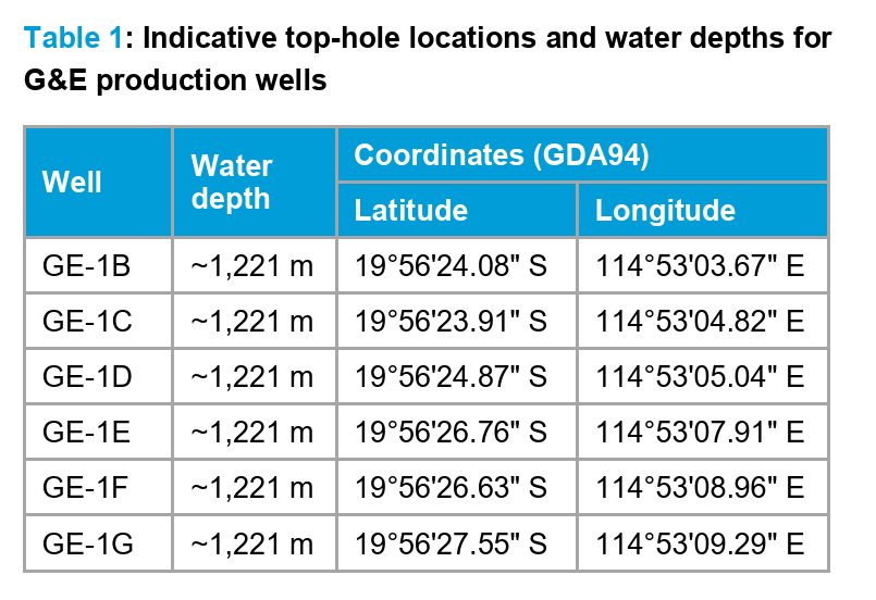
Table 1 provides indicative top-hole locations for the G&E production wells.
The Operational Area (OA) in which the petroleum activity will be undertaken is defined as a 5 km radius buffer around the indicative top-hole locations for the G&E wells.
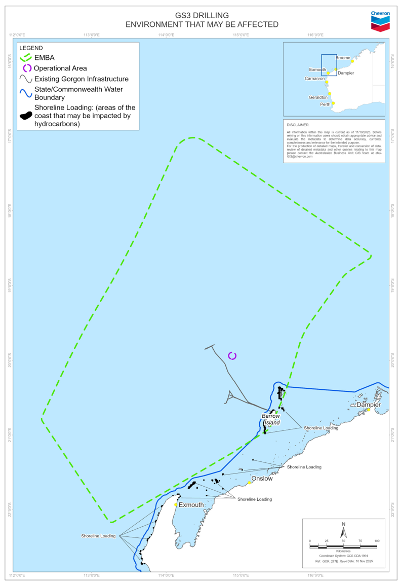
Figure 1 and Figure 2 show the location of the OA.
[3] This retention lease will be converted to a production licence prior to commencement of the petroleum activity. This process is administered by the National Offshore Petroleum Titles Administrator (NOPTA).
schedule and duration
GS3 drilling and completions are indicatively scheduled to commence from early-2027 and will take approximately 12-18 months to complete. The drilling and completions may occur as a single campaign or over multiple campaigns.
This timing is indicative and subject to MODU/vessel, infrastructure or equipment availability, SIMOPS schedules, delays caused by weather events, and other unforeseen factors.
The petroleum activity can occur 24 hours per day and 7 days per week.
safe navigation area
Marine notices will be issued prior to drilling activities commencing within the OA. The notices will include a request to other marine users for a 500 m safe navigation area (temporary exclusion) around the MODU.
No permanent exclusion zones will be sought for the new production wells.
environment that may be affected (EMBA)
As part of our environmental assessment and consultation process, Chevron Australia creates maps to provide geographical context for relevant persons to determine if their functions, interests or activities may be affected by an offshore petroleum activity during planned activities (e.g. routine or contingency operations) or from an unplanned event (e.g. emergency scenarios).
The majority of the environmental impacts or risks arising from planned activities would occur within, or within proximity of, the OA. However, for unplanned events the geographical extent may be much broader.
Figure 2 shows the EMBA, which is based on worst-case unplanned hydrocarbon release (oil spill) scenarios resulting from either a vessel collision or loss of well control event.
The EMBA has been defined through combining multiple oil spill model simulations for the unplanned release scenarios under different weather and ocean conditions. This means that in the highly unlikely event an unplanned release does occur, a geographical area much smaller than the EMBA would be affected.
Chevron Australia has systematic control measures to prevent and mitigate emergencies, and to reduce the impact and risks of planned activities on the environment, including to ecological, social and cultural sensitivities.
Table 2 summarises the potential impacts and risks and proposed control measures to manage these to levels that are as low as reasonably practicable (ALARP) and acceptable.
marine fauna and biologically important areas (BIAs)
Chevron Australia has undertaken environmental and modelling studies and considered scientific advice and government guidance (including conservation management and recovery plans) in assessing potential impacts and risks to marine fauna.
As with most offshore areas in WA, a range of marine species are likely to be present or transit through the OA and EMBA. Marine fauna may include various mammals (whales, dolphins), fishes (including sharks and rays), reptiles (turtles, sea snakes), seabirds and shorebirds species.
Some of these marine fauna species are also protected (listed as threatened and/or migratory) under the Environment Protection and Biodiversity Conservation Act 1999 (Commonwealth [Cth]).
BIAs are areas used by protected marine species for carrying out critical life functions (e.g. reproduction, feeding, migration, resting).
The OA occurs within the migration BIA for the pygmy blue whale. An Adaptive Management Framework [Appendix 1] will be implemented to manage potential risks of underwater sound from GS3 and SIMOPS activities, such that they are not inconsistent with the Conservation Management Plan for the Blue Whale.
The OA also intersects the breeding BIA for the wedge-tailed shearwater.
The other closest BIAs include the interesting buffer BIA for flatback turtles, foraging BIA for whale sharks, and the migration BIA for humpback whales, located ~19 km, ~20 km, and ~48 km respectively from the OA.
The closest nesting habitats for turtle, seabird or shorebird species are Montebello Islands and Barrow Island, ~47 km and ~58 km respectively from the OA.
The broader EMBA intersects with the BIAs for:
- mammals—pygmy blue, humpback, and southern right whales, dugong
- reptiles—flatback, green, hawksbill, and loggerhead turtles
- fishes—whale shark
- seabird and shorebirds—fairy, lesser crested, and roseate terns, and wedge-tailed shearwater.
cultural values
Chevron Australia acknowledges that Traditional Owners and Custodians in the northwest region of WA have expressed a cultural and spiritual connection to Sea Country. This encompasses an obligation to protect cultural values and features — including songlines, dreaming stories, and the flora and fauna connected to them (tangible and intangible).
We are committed to ongoing engagement and consultation with relevant groups to help protect these cultural values. This process will continue to inform our understanding and help facilitate the co-design of appropriate controls to avoid impacts.
Chevron Australia’s Cultural Heritage Management System (CHMS) sets out processes and procedures to manage risks to cultural heritage, and Chevron Australia’s obligations under relevant legislation including the Aboriginal Heritage Act 1972 (WA) and the Underwater Cultural Heritage Act 2018 (Cth).
The CHMS includes governance of field surveys and monitoring, spatial data, compliance and assurance, heritage assessment, inadvertent discovery procedures, incident management, training and induction materials.
approvals process
Petroleum activities in Commonwealth waters are regulated by NOPSEMA. Before petroleum activities can take place, Chevron Australia must develop an EP which will be assessed by NOPSEMA in accordance with the requirements of the Offshore Petroleum and Greenhouse Gas Storage (Environment) Regulations 2023 (the Regulations).
The Regulations require us to consult with relevant persons whose functions, interests and activities may be affected by the petroleum activity.
Following consultation, we will submit the GS3 Drilling EP to NOPSEMA, which will:
- describe the petroleum activity;
- describe the environment that may be affected by the petroleum activity;
- identify and assess potential environmental impacts and risks arising from the petroleum activity;
- identify control measures to manage the potential environmental impacts and risks to levels that are ALARP and acceptable; and
- outline how Chevron Australia has engaged with relevant persons and how their feedback has been considered and addressed.
NOPSEMA will assess whether the EP satisfies the Regulations, including whether the environmental impacts and risks of the petroleum activity will be managed so that they are ALARP and acceptable before accepting the EP.
impacts, risks and proposed controls
A summary of potential impacts and risks and proposed control measures for GS3 Drilling can be viewed in Table 2.
your input
We are now seeking your feedback and input if you consider your functions, interests, or activities may be affected based on the information provided, including the summary of the key environmental impacts and risks identified to date in Table 2.
We encourage you to provide additional details about the environment, aspects, consequences of the activity or control measures or to ask for further information or consultation by 20 January 2026.
You can contact us with any questions, requests for information, or to provide feedback by calling tollfree on 1800 225 195 or online below.
Relevant persons may request that the information they provide be treated as confidential. Chevron Australia will make this known to NOPSEMA and it will be identified as sensitive information and not published in the EP.
what's next
The feedback we receive during consultation will be used to inform and enhance the EP before it is submitted to NOPSEMA for assessment.
We commit to keeping you informed and providing responses to any relevant person who so requests.
privacy notice
If you choose to provide feedback on this proposal, Chevron Australia will collect your name and contact details, in addition to your comments, for the purposes of maintaining contact with you and inclusion of your feedback in our submission to NOPSEMA. Provision of this information is purely voluntary, however if you choose not to provide it, we may not be able to contact you in the future regarding your submission. Chevron may transfer your information to NOPSEMA, if required and if you do not identify it as sensitive, and to other Chevron affiliates including our head office based in the United States. For further information regarding how we protect your personal information, and your rights, please refer to our privacy notice.
further information
Figure 1: Operational Area and Indicative Production Well Locations.

Figure 2: Environment that may be affected (EMBA).

Table 1: Indicative top-hole locations and water depths for G&E production wells. – view here
Table 2: Summary of potential impacts and risks and proposed control measures for GS3 Drilling. – view here
Appendix 1: Adaptive Management Framework for Pygmy Blue Whales exposed to underwater sound emissions from the Gorgon Backfill Fields Development. – view here
resources
- GS3 Drilling - info sheet - October 2025 pdf opens in new window
- Consultation on Offshore Petroleum Environment Plans – NOPSEMA pdf opens in new window
- Environment plan content requirements – NOPSEMA pdf opens in new window
- Environmental requirements – NOPSEMA opens in new window
- Offshore Petroleum Greenhouse Gas Storage (Environment) Regulations opens in new window
- Chevron Operational Excellence Management System (OEMS) opens in new window
- Consultation in the course of preparing an environment plan – NOPSEMA pdf opens in new window